Walks & Trails
Due to Ilkley's position in beautiful Lower Wharfedale, there are some superb walks beginning here, whether they be easy riverside strolls or longer moorland rambles. Thanks to the farsightedness of the Parish Council in the last century, who purchased the moor as a public open space, there are walks suitable for the young and old alike. Whilst the routes described in this section have been compiled to enable you to enjoy the scenery fully, we suggest you purchase an Ordinance Survey map of the area from one of the bookshops or newsagents in the town.
Three trails, Riverside Walk (walk 1below), Nature Trail on Ilkley Moor and Geology Trail on Ilkley Moor (combined in walk 2 below), were established by the Wharfedale Naturalists and trail leaflets are on sale at the Tourist Information Centre and at White Wells.
2. White Wells, Rocky Valley, Cow and Calf Rocks and the Tarn
3. Hebers Ghyll and the Swastika Stone
4. Prehistory Trail on Ilkley Moor
5. Mount Calvary and Middleton Woods
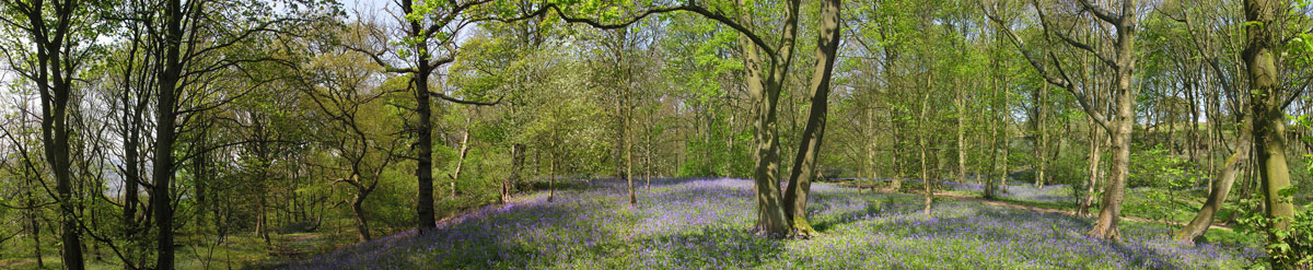
7. Middleton, Fairy Dell and Denton
8. Ilkley to Dick Hudsons and back
9. The Swastika Stone, Doubler Stones and the River Wharfe
1. Riverside Circuit: Allowing 2-3 hours, this pleasant, easy access 3 mile (5km) walk is suitable for pushchairs and wheelchairs, with good paths on both sides of the river. If you start at the New Bridge, go through the Riverside Gardens to the Old Bridge then, along the other side, head downstream, crossing the road at the New Bridge, and on to the footbridge at Crumwheel. Return to Ilkley on the bank nearest the town, the south bank. For wildlife and flora see the Naturalists' new colour leaflet.
2. White Wells, Rocky Valley, Cow and Calf Rocks and the Tarn: Allow 2 hours for the 3 mile (5km) walk. From the cattle grid on Wells Road, go past the paddling pool up the steep hillside to the white buildings of White Wells. Follow the track behind White Wells that goes through Rocky Valley - bearing left at the steps. Cross Backstone Beck over some rock slabs and across (half left) to the top of the Cow and Calf Rocks. Keeping height, turn left along the edge to a wooden stile among the pines, then descend to a lower path and a wooden bridge, which takes you to the tarn. The tarred path from the tarn leads back to Wells Road.
3. Hebers Ghyll and the Swastika Stone: Allow 2 1/2 hours for the 3 1/2 mile (5 1/2 km) walk with a steady climb. From The Grove, continue along Grove Road, past some fine Victorian houses with 'Heathcote' on the right, built by Sir Edwin Lutyens as a private residence and now offices. Follow the road round, past all the houses, to the foot of Hebers Ghyll. Take the path up alongside the stream, which crosses and re-crosses it by small wooden bridges. At the top is a chalybeate well. Go through the kissing gate onto the moor and half right up through the bracken. You will see the old iron railing on the cliff edge that protects the Swastika Stone. Return to the top of Hebers Ghyll, then continue past Panorama Reservoir and along the edge of the moor. Cross Spicy Gill and join the Keighley road down to Wells Road, past the college and into Ilkley.
4. Prehistory Trail on Ilkley Moor: Allow 2 1/2 hours for a 4 mile (6 1/2km) walk, starting at the Cow and Calf car park. Go to the left of the Cow and Calf quarry and, bearing slightly left, go ahead to the next ridge and the Haystack Rock, the top of which is covered with cup marks. Follow the track first to the right, then curve round to the Bronze Age hut circles of Green Crag Slack (opposite a green storage hut). Continue up through the bracken, swinging right, across a rising shelf of heather to cross a line of shooting butts and join the main track (with board walk) to Dick Hudsons. The single boundary stone on the next ridge is Lanshaw Lad, where the well-worn track bears left to the Neolithic stone circle of the Twelve Apostles.
About 150 yards (137m) beyond the circle, at the small cairn, branch left through the heather alonside a drainage ditch. Otley Chevin is in the distance and Almscliffe Crag to the left. Descend to cross the top of the Higher Lanshaw Dam, which holds a small reservoir. Drop down before reaching the end of the dam along a path to Lanshaw Lass, marked by a yellow post on the highest point of the horizon ahead. As you approach this point, the length of Lanshaw Delves stands out like a long green embankment, contrasting with the heather and cottongrass in front of it. This is a fine lateral moraine of the Wharfedale glacier. In the past, it was dug into for limestone boulders, which were burnt in small lime kilns along the ridge - hence the delves. Near the yellow post and hidden in a hollow is the fallen boudary stone of Lanshaw Lass.
From here follow two more yellow boundary posts along a broad path to the large rock of Green Crag. There are many cup and ring marked rocks in this area. Drop down from Green Crag, bearing left, and look out for the Idol Stone, almost on the path and covered in cup marks. The path leads back to the Haystack Rock and, beyond that the Cow and Calf car park.
5. Mount Calvary and Middleton Woods: Allow 2 1/2 hours for the 4 miles (6 1/2km). From Brook Street cross the road at the traffic lights and go down to the New Bridge. Cross the bridge and continue up the river on the far bank. At the road, cross over and walk up Owler Park Road as far as High Austby. At the top, go through the gate on the right, through fields and woods to Mount Calvary, a wooden door on the left leading to a series of Italian sculptures, which represent the Stations of the Cross. Return to the entrance and go straight across to reach Myddleton Lodge, for centuries home of the Middleton family, who were lords of the manor. At Hardings Lane, turn left, then right along the road to a stile on the right, near the Hollies. Go half left through the field and into the upper part of Middleton Woods. Cross Curly Hill, then the lower wood, to drop down to the corner of the swimming pool. Cross Denton Road and the playing field to the riverside, the New Bridge and Brook Street.
6. Addingham and Nesfield: Allow 4 hours for the 7 mile (11km) walk. From Brook Street, cross the traffic lights to the New Bridge. Turn left through the Riverside Gardens to the Old Bridge. Still on the left side of the river follow the sign for the Dales Way. The path leads to the tennis club where, on the left is an iron gate and path that leads through fields, up river. About a mile (1 1/2km) further on, turn right along the old Addingham road. Turn right again and go between former weaver's cottages and alongside the river again to Addingham Church. At the road, turn right and follow the footpath sign down to the suspension footbridge across the River Wharfe. Cross the bridge and, on reaching the road, turn right. After half a mile (3/4km) you will reach Nesfield village. Continue along the Ilkley road for another 200 yards (182m) and take the gate on the left contour along to Low Austby, then Owler Park Wood and on to Owler Park Road. At the bottom of the road, corss to the riverside footpapth and back to Ilkley.
7. Middleton, Fairy Dell and Denton: Allow 4 1/2 hours for an 8 mile (13km) walk. From Brook Street, cross the traffic lights to the New Bridge, turn right by the river and cross the road into Middleton Woods. Climb up to Curly Hill, walk up the road and straight across Slates Lane at the top. The narrow lane through the hamlet of Middleton leads to Hill Top Farm. Turn right on a track to West Moor House and 100 yards (91m) beyond, turn right again down through the field to cross Fairy Dell. Just before the next farm do a U-turn through a gate and up two large fields with the wall on the right. At the top, turn right with open moor to the left and a wall still on the right. Just before a woodland plantation, join a double track down the hill to Denton village. The return path to Ilkley starts just before reaching the village. It passes through fields and woodland, over Bow Beck and above what was formerly Middleton Hospital, which was demolished recently. Return by turning left at the lane in Middleton and back to Ilkley down Curly Hill and through Middleton Woods.
8. Ilkley to Dick Hudsons and back: 4 miles there and 4 miles back (total of 13km), allow 2 hours each way. A famous walk that follows an ancient route. Go up Wells Road to the cattle grid, then up the hillside to White Wells. Take the path to the rear of these white buildings towards Ilkley Crags and up the steps to a cairn at the top. Go forward along a broad track, partly a board walk, past the boundary stone of Lanshaw Lad and the Twelve Apostles stone circle. Ahead is Baildon Moor with Otley Chevin to the left. Cross a wall by a stile and continue to a rough walled track down to the road opposite Dick Hudsons, a family pub with bar food. Return by the same route.
9. The Swastika Stone, Doubler Stones and the River Wharfe: Allow 5 1/2 hours for the 9 mile (14 1/2km) walk. Start up Wells Road, past the college and branch left up the Keighley road to the path along the moor edge. At Panorama Reservoir, strike up away from the wall to pass the Swastika Stone in its iron railing. The path from here is ideal walking with wonderful views of Wharfedale below. Pass Piper's Crag and Noon Stone to Windgate Nick at the far end of the ridge. Here, turn left over the stile in the wall to visit the Doubler Stones. Return to the same wall, but to the right, and cross the path you came along to Windgate Nick. Descend through the quarry (there are still some old millstones lying about this area) and down the fields to Moorside Lane. Turn right past Cragg House Farm (with the date 1695 over the door) and 200 yards (182m) further on go left through a gate and diagonally across and gently down to Ramsgill Cottage and Netherwood House, through the yard and gate beyond. The route continues staight across the driveway again and contours along the field boundary, then diagonally down to the far corner and the main A65 Ilkley/Skipton road. Take care crossing and proceed along the footpath to the River Wharfe. Turn right along the Dales Way path back to Ilkley.
10. Beamsley Beacon: For the longest of these walks, about 11 miles (17 1/2km), allow a whole day, or 6 hours of walking. The first part - to the footbridge at Addingham - is the same as walk 6, following the Dales Way. Go over the footbridge and to the Ilkley/Beamsley road and continue straight on for 200 yards (182m) up the road to a footpath sign on a bend. The route carries on up the hillside bridleway to emerge through a farmyard on to the Langbar road. Turn left up the winding road and, at the highest point, strike up the wellworn moor path (right) to Beamsley Beacon to gain spectacular views up the dale. Return to the road and, after 200 yards (182m), keep straight on along a rough track. This is known as Badgers Gate (badger here meaning a pedlar). Follow the ancient route above the intake wall, curving round slightly, then striking out past an ancient milestone on an easy to follow track that comes out at Hill Top Farm, Middleton. Go down the surfaced lane through the hamlet of Middleton, crossing Slates Lane and down Curly Hill. The last part of the walk can be made down through Middleton Woods to the riverside and back to Ilkley New Bridge.
The Dales Way: Founded in 1968 by Colin Speakman of Ilkley, in co-operation with the Ramblers Association, this long distance footpath goes from Ilkley Old Bridge to Bowness-on-Windermere in the Lake District. Much of the 80 miles (128km) keeps to the valleys and riversides, for which the average walker may take from five to seven days. It follows the River Wharfe through the Yorkshire Dales National Park, brushes with the Pennine Way, then goes down Dentdale into Cubrian to cross the River Lune and enter Lakeland.